Getting to know Hoi An
UNESCO recognised this old trading town in 1999 as among Southeast Asia's most intact surviving ports, and a walk through its centre explains the listing without much need for commentary. Merchant houses raised by Chinese trading families sit a few doors from a small arched bridge the town's Japanese residents once built, and colonial-era plasterwork from the French decades fills the gaps in between, packed into a walkable core you can circle in under half an hour.
One clarification worth stating plainly: Hoi An shares no watershed with the Mekong. The Thu Bon, the waterway that gives this town its riverfront, drains its own catchment and meets the sea a short way downstream, well removed from Laos, Cambodia or the delta country south of Ho Chi Minh City. It appears in this guide because almost every itinerary tying central Vietnam to the south passes through here, sometimes continuing on to a Mekong Delta segment, and for no reason connected to the river itself.
A separate change worth flagging: the mid-2025 wave of provincial mergers redrew the map around here as well. Quang Nam, the province that used to contain both this town and the My Son ruins, was absorbed into a larger Da Nang, putting both sites under Da Nang's administrative umbrella instead of a province of their own. Nothing on the ground has changed; only the line on the map has.
Things to see and do
Chua Cau, the Japanese Covered Bridge
A small roofed bridge raised by Hoi An’s Japanese trading community in the 16th century, and the closest thing the town has to a single defining landmark.
Chinese assembly halls
Ornate meeting houses built by different Chinese congregations, layered with carved timber, ceramic roof figures and incense coils.
Tan Ky ancient house
A merchant house nearly two centuries old, still lived in by the same family, open for a guided look at how a trading-era home was laid out.
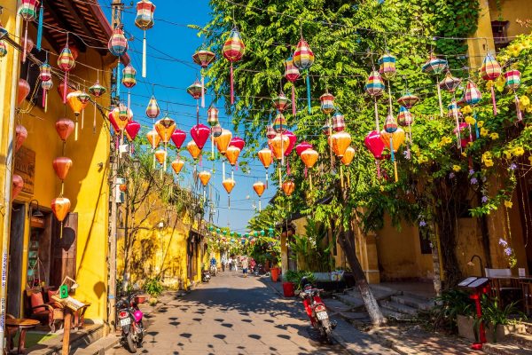
Lanterns after dark
Once the streetlights dim and the paper lanterns take over, the riverside cafes and the old bridge look almost nothing like they do at noon.
Tra Que vegetable village
A working herb and vegetable village a short bike ride out of town, where a few farms take visitors out to plant and harvest alongside them.
Thanh Ha pottery village
A riverside village that has thrown terracotta pots for generations, with a small workshop area open to visitors.
Bay Mau coconut forest and basket boats
Round woven basket boats spin visitors through a coconut-palm waterway; worth knowing before you book, this stretch is now heavily touristed and loud through the middle of the day, so go at opening time if quiet water is the point.
An Bang Beach and Cua Dai Beach are both a quick trip out of the centre and answer very different needs. An Bang has held up well, lined with beach bars and clean sand. Cua Dai has not fared the same: coastal erosion has chewed through much of its shoreline over the years, leaving stretches roped off or reduced to a patchy strip rather than the wide sweep older brochures still promise, so An Bang is the safer pick of the two.
My Son, a cluster of Cham temple ruins set among hills, sits about 40 km from Hoi An and is usually visited as a half-day trip by car, ideally in the early morning before the heat and the tour groups build up.
Good to know
| What | Detail |
|---|---|
| Old town entry | Covered by a single ticket system that also grants entry to several of the historic houses and assembly halls |
| Wet season | October through December brings the heaviest rain and the highest chance of Old Town flooding along the riverfront streets |
| Airport | Da Nang International Airport, roughly 30 km away; there is no local airstrip |
| Getting around | Bicycle and on foot within the pedestrianised old quarter; taxi or ride-hailing app for the beaches and villages |
| My Son | About 40 km from Hoi An, best visited early in the morning |
Trips that include Hoi An
None of our packages list Hoi An on their own; it always rides along with a Da Nang base, whether as a single excursion or a night or two tacked on. Let us know how much time you want in the old quarter and we will build it into the schedule around Da Nang and Hue.