Getting to know the Mekong Delta
By the time the Mekong crosses into Vietnam it has already given up most of what made it a single river further north. It splits, rejoins, splits again, and finally drains to the sea through a fan of channels that once numbered nine, which is why the Vietnamese name for this stretch is Cuu Long, the Nine Dragons. Two of those original mouths have since silted up and are no longer navigable, so the nine-channel story is history rather than a count you can still verify on a map. What is left is still a lattice of rivers, canals and man-made waterways dense enough that in parts of the delta a boat remains the shortest way between two points, even with a paved road running alongside it.
This plain grows the rice that feeds the rest of the country and exports besides, along with a share of Vietnam’s fruit that is out of proportion to the delta’s size on a map. Sediment carried down from the Mekong’s upper basin built the soil, and the canal network, much of it dug or widened under French rule and again after 1975, turned that soil into some of the most intensively farmed land in Southeast Asia. Rice paddies run in tight, low blocks between orchards of durian, rambutan, dragon fruit and pomelo, and a farmer’s working day is still set by the tide as much as the clock in the parts of the delta closest to the coast.
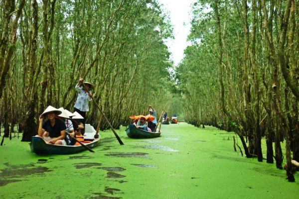
None of that scenery needs a mountain or a monument to be worth the trip. What it needs is time on the water: a boat out to an orchard, a paddle down a canal narrow enough that the palm fronds meet overhead, a morning at a market that still runs, at least partly, by boat. The rest of this page covers what has actually changed here since the last time a guidebook was written, because a fair amount of it has.
Things to see and do
The delta rewards spreading a visit across more than one town, since no single stop covers what the region does well. These five are where most itineraries build from.
Beyond those five towns, the pull of the delta is mostly in what happens between them: an hour on a dugout boat down a canal too narrow for anything with an engine, a stop at an orchard where the fruit on your plate came off the tree that morning, a night at a homestay where dinner is whatever the family cooked for themselves. Floating markets get most of the attention in guidebooks, and they are worth seeing, but treat the description below as the honest version rather than the postcard one.
Good to know
| What | Detail |
|---|---|
| Administrative map | Since 1 July 2025: Can Tho city (absorbed Soc Trang and Hau Giang), An Giang province (absorbed Kien Giang, capital moved to Rach Gia), Vinh Long province (absorbed Ben Tre and Tra Vinh), Dong Thap province (absorbed Tien Giang, capital moved to My Tho), Ca Mau province (absorbed Bac Lieu) and Tay Ninh province (absorbed Long An) |
| Phu Quoc | Now a special zone (dac khu) under An Giang province, not a city under Kien Giang |
| Getting there | Highway from Ho Chi Minh City to Can Tho, about 2 hours; Can Tho International Airport currently has no international routes, so all international arrivals fly into Tan Son Nhat in Ho Chi Minh City |
| Rach Mieu 2 bridge | Opened 19 August 2025, shortening the road route into the eastern delta |
| Wet season | September to November, when low fields and canals flood and a boat becomes the practical way to get around |
| Dry season | December to April; peak saltwater intrusion falls late March into April, hitting Ca Mau hardest as the province furthest downstream |
| Fruit season | May to August is the peak for rambutan, durian, mangosteen and longan, though something is in season most of the year |
| Floating markets | Genuinely shrinking; see the note below before you set an alarm for one |
Trips that include the Mekong Delta
Every one of these can be shortened, lengthened or combined with a Saigon stay on either end. Tell us how many days you have and whether an early floating-market start matters to you, and we will build the route around it.